Finding fresh stumps on the wrong side of a line is one of the most stressful things a landowner can walk up on. The first reaction is usually to call the logger, the neighbor, or the sheriff — sometimes all three at once. Slow down. What you do in the first few days shapes everything that follows: the documentation, the value opinion, and whether the evidence on the ground is still readable a month from now.
This Field Note walks through the practical steps for Mississippi and Alabama landowners who suspect timber was cut across a property line. It is forestry guidance, not legal guidance — the focus is on what to record, what to leave alone, and when to bring in a consulting forester.
Stop Before You Clean Anything Up
The single most common mistake we see is a landowner walking the cut and starting to tidy — stacking slash, pulling flagging, dragging tops out of the way. Every one of those actions removes evidence. Stumps, slash piles, skid trails, and decking areas are all part of the field record. Once they are disturbed, no one can put them back the way the logging crew left them.
If the cut is fresh and the crew is gone, the right next move is to step back, take wide photos of the disturbed area from several angles, and stop walking around in it. Mark your entry point and leave the scene as close to how you found it as you can.
Document What You Can See From Your Side of the Line
Document broadly before you document narrowly. The goal is to create a record that holds up months later when the slash has flattened and the stumps have grayed:
- Wide photos of the cut showing context — your boundary, the disturbed area, any standing timber left behind.
- Photos of any flagging, paint, or marks the logging crew used.
- Photos of access points: gates, woods roads, decking areas, mud tracks onto the public road.
- Any tags, ribbon, or buyer paint visible on remaining timber or stumps.
- GPS points on stumps, corners, and access locations using a phone GPS app or handheld unit.
- The date and approximate time of every visit.
If you do not yet know exactly where your line runs, that is fine — note what you believe the line to be and photograph it. The timber trespass and damage appraisal work that follows will tie those photos back to the deeded boundary.
Confirm the Boundary Before You Make Accusations
Plenty of suspected trespass turns out to be a boundary that has drifted over decades — a fence built for convenience, a logging road that wandered, a corner everyone in the family pointed at that does not match the deed. Before contacting the adjacent owner, the logger, or law enforcement with a trespass claim, confirm where the line actually is.
That usually means pulling the deed, the most recent survey if one exists, and any plats from prior timber sales. On older inherited tracts a fresh survey may be the only way to settle the question. The deeded line, not the working line, is what controls the documentation that follows.
Call a Registered Forester Early
The earlier a forester is on the ground, the better the record. Stumps weather, sap stops running, and slash collapses within weeks. We routinely see cases where the landowner waited 90 to 120 days before calling, and by then key indicators — fresh-cut color on the stumps, recent skid impressions, residual paint — are gone.
A forester on a suspected trespass walks the cut and records what is documentable: stump count by species and diameter, product class of what came off, cut age based on weathering, access route used, GPS positions, and any remaining flagging or paint. That field record is the foundation for a value opinion later on.
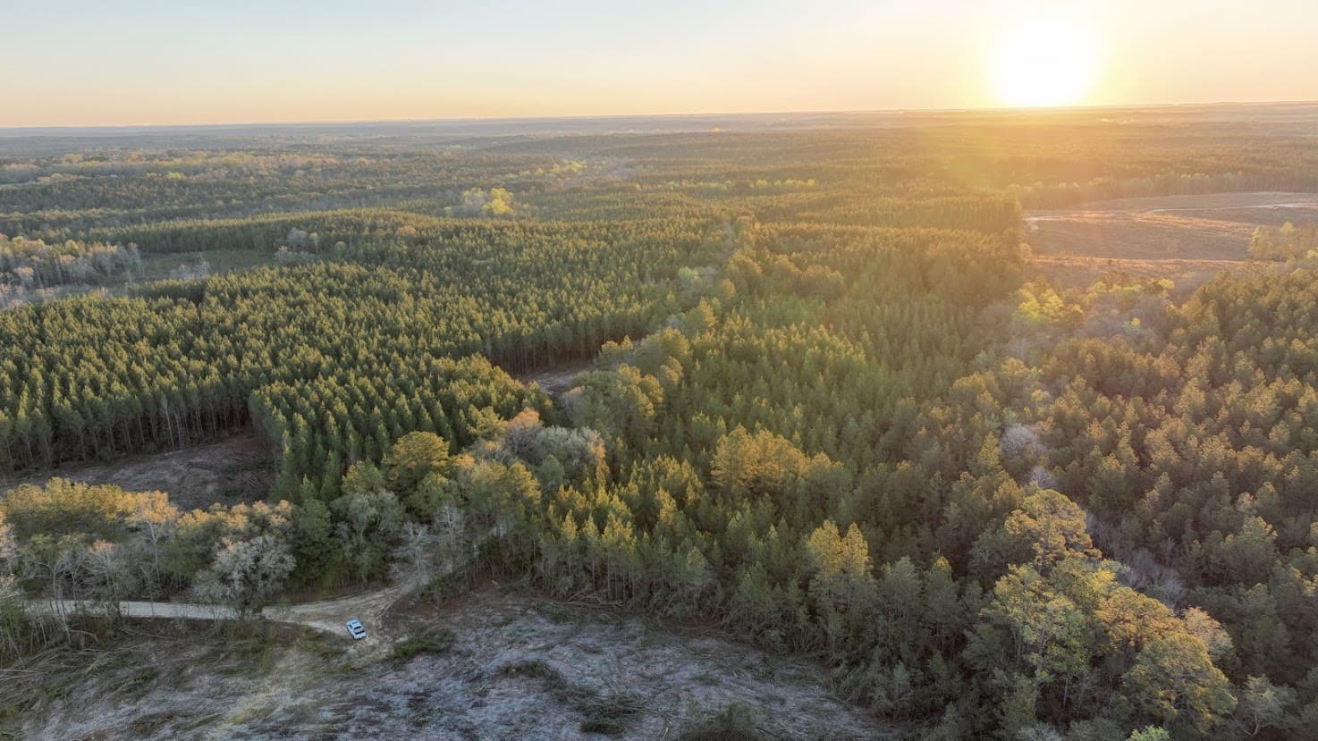
Aerial Imagery Can Lock the Date
One of the most useful tools on a fresh cut is drone imagery. A single flight captures the disturbed area as it sat on a specific date — boundary relative to the cut, slash distribution, skid trails, decking location, and approach roads. Cross-referenced against historical satellite imagery, the flight establishes a clear before-and-after picture that is far harder to argue with than a written description.
Drone imagery also helps in cases where the cut crosses heavy brush, water, or rough ground that is hard to walk and photograph from the ground. A 20-minute flight covers what would take a full day on foot.
Key Takeaways
- Stop, photograph, and leave the scene alone before anyone begins cleanup.
- Confirm where the deeded line actually runs before making a trespass claim.
- Stump color, slash, and sap indicators degrade within weeks — call a forester in days, not months.
- Wide photos, GPS points, and an early aerial flight create a record that survives weathering.
- Forestry documentation supports decisions; it does not replace the legal review you and your advisors will run separately.
Talk With a Forester About Your Tract
If you suspect a cut crossed your line, a brief call helps us figure out whether the situation is a working trespass, a boundary question, or both — and what to protect on the ground in the meantime. Reach Southeast Forestlands for a timber trespass and damage appraisal walk-through, or browse our field case studies for examples of how we handle documentation on the ground.