How Drones Help in Managing Forestlands
Forests are crucial to the survival of many animal and plant species. Additionally, they serve as a natural buffer against natural disasters such as floods and landslides. Conserving forests protects diverse ecosystems and wildlife. It also maintains a sustainable timber supply and a reliable water supply for future generations.
Managing forested properties is a challenging task that requires careful thought and consideration, especially when balancing economic growth and ecological sustainability. Fortunately, modern technology has provided a powerful tool for forestry management: drones. As landowners are primarily responsible for overseeing and managing their forested properties, the use of drones can greatly assist in this task.
Drones have become increasingly popular in the forestry sector. As a result, they are helping people collect forest data more efficiently and accurately. In this blog, we will take a closer look at how drones help manage forestlands effectively. From conducting aerial surveys and mapping to monitoring forest health and identifying potential threats, we will explore the diverse applications of drones in streamlining forest conservation efforts.
Monitoring Drones
Utilizing drones in forestry management has significant benefits. Firstly, the ability to effectively monitor and assess forest health is improved. Drones equipped with specialized sensors and cameras can capture detailed aerial photographs, providing valuable insights into forest conditions. Additionally, landowners can identify infestations, diseases, and other stressors by analyzing these images. They can also pinpoint specific areas that require immediate attention.
Moreover, drones offer a unique advantage in terms of efficiency and cost-effectiveness. Compared with traditional methods such as intensive ground surveys, which are time-consuming and expensive, drones can cover larger areas in less time. This makes them a more efficient and cost-effective option. Therefore, with this capability, landowners can quickly identify potential problems and subsequently take action to maintain the health and well-being of their forests.
With the ability to detect forest health issues promptly and accurately, drones have revolutionized forestry monitoring. They provide landowners with a powerful tool to proactively manage and protect their valuable forest resources. This contributes to sustainable forestry practices and environmental conservation.
Mapping
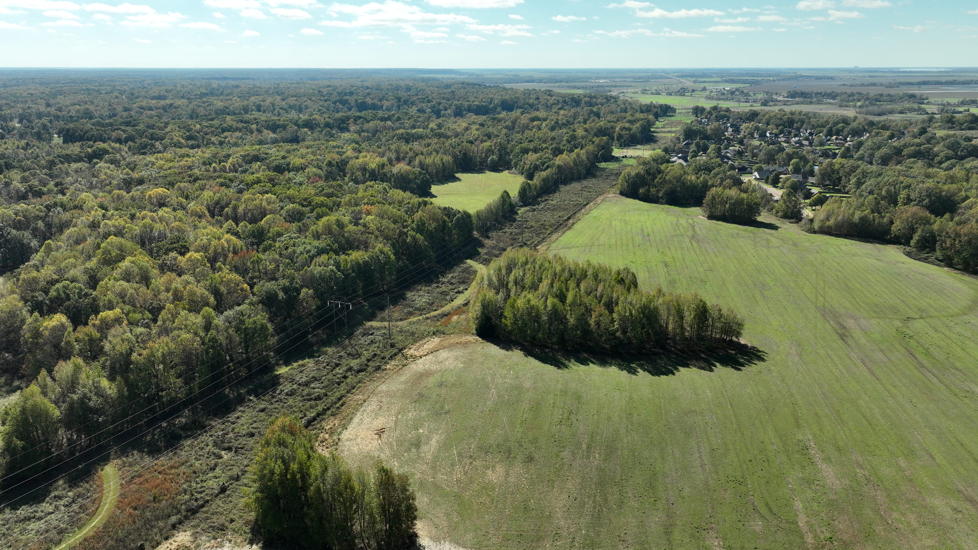
Drones are not only powerful tools for mapping forestlands, but they also offer a multitude of benefits. The high-resolution imagery captured by drones offers a unique opportunity to create detailed maps. These maps reveal the contours of the land and the intricate network of water sources. These maps also showcase the delicate ecosystems thriving within. By capturing this level of detail, landowners can gain a comprehensive understanding of the diverse flora and fauna. These forestlands are home to a variety of species.
Additionally, these detailed maps enable landowners to track changes in the forest over. This empowers them to make informed decisions about improvements, transitions, and adaptive management strategies. With this valuable information at their disposal, landowners can effectively steward these natural resources, ensuring their sustainability for future generations.
By harnessing the capabilities of drones, landowners can unlock a new level of insight and appreciation for their forestlands. Additionally, drones offer an innovative and efficient way to manage and preserve valuable ecosystems. Moreover, they can identify potential areas for restoration and monitoring wildlife populations. With each aerial survey, a wealth of data is collected. Consequently, this data contributes to growing knowledge about our forests and their intricate dynamics. By harnessing the capabilities of drones, landowners can unlock a new level of insight and appreciation for their forestlands. Additionally, drones offer an innovative and efficient way to manage and preserve valuable ecosystems. Moreover, they can identify potential areas for restoration and monitoring wildlife populations. With each aerial survey, a wealth of data is collected. Consequently, this data contributes to growing knowledge about our forests and their intricate dynamics.
Integrating drone technology into forest management practices is a significant leap forward. Moreover, it enhances our ability to understand and protect these vital natural resources. As we explore the potential of drones, we unlock unprecedented possibilities for sustainable land use, conservation, and ecological research.
Planning
Drones can be crucial to creating sustainable, highly effective forest management plans. By capturing highly detailed aerial footage, drones provide a comprehensive, panoramic view of the forest, enabling a thorough analysis of its condition. This imagery allows for identifying specific areas that require attention, such as overgrowth, dead or diseased trees, or even the impact of invasive species. By precisely mapping these areas, drones facilitate the development of targeted remediation or long-term management strategies, ensuring the optimal health and preservation of the forest ecosystem.
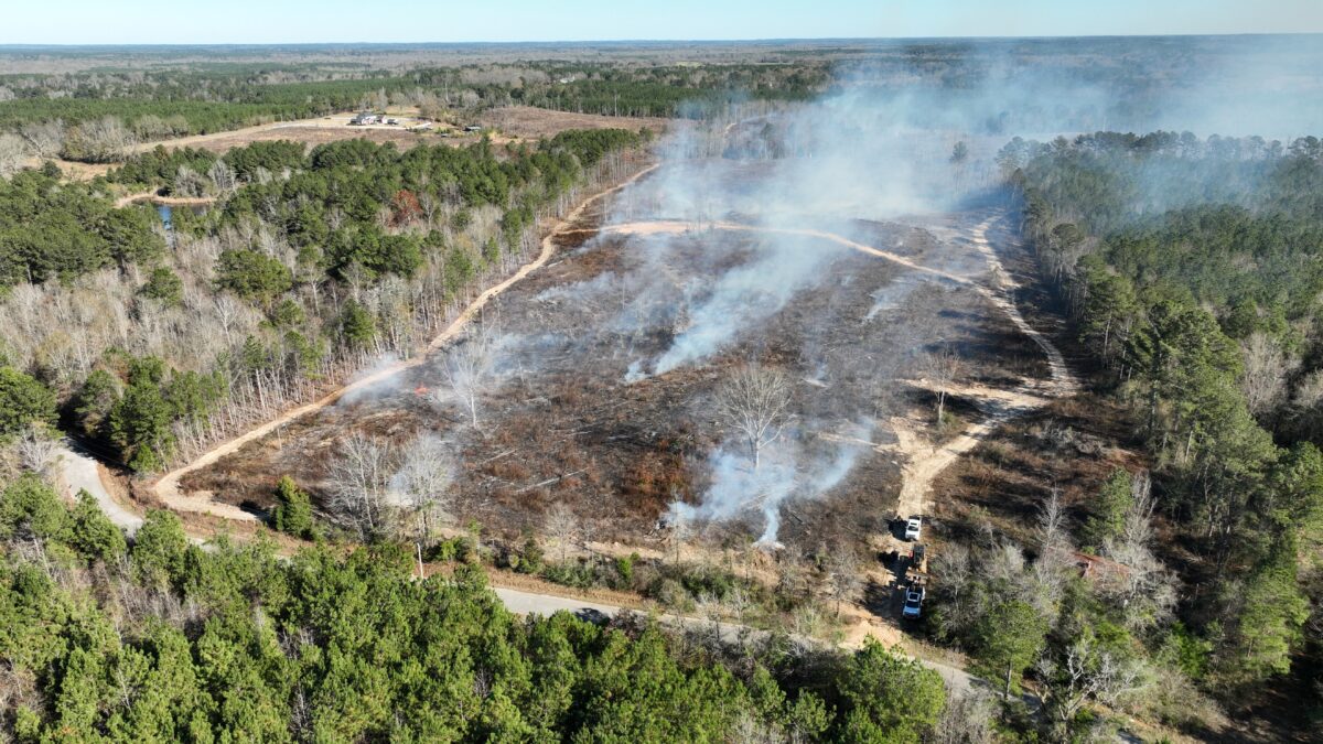
Moreover, drone mapping technology also plays a vital role in identifying areas particularly vulnerable to wildfires. By capturing accurate data on vegetation density, soil moisture, and other key factors, drones enable informed decisions regarding implementing firebreaks or other preventative measures. This detailed information helps forest managers and fire response teams to effectively allocate resources and prioritize areas for intervention, mitigating the potential impact of wildfires and safeguarding valuable natural resources.
With their ability to gather precise data and provide valuable insights, drones have become an invaluable tool for preserving, protecting, and sustainably managing our forests. By leveraging the capabilities of these aerial devices, we can enhance our understanding of forest ecosystems, support evidence-based decision-making, and foster a more resilient and harmonious coexistence with nature.
Cost-Effective
Drones can potentially revolutionize forestry management for landowners by providing an unparalleled perspective. With their bird's-eye view of forestlands, drones empower landowners to swiftly identify specific areas needing attention. They can then allocate resources with utmost precision. Equipping drones with specialized sensors or cameras saves valuable time compared to traditional ground inspection methods. It also provides highly detailed information that would otherwise be challenging, if not impossible, to collect. This enables landowners to make informed decisions. They can take proactive measures to preserve and sustainably manage forest ecosystems.
Moreover, drones offer remarkable capabilities beyond data collection. Drones can monitor forests for risks such as wildfires and pests and intervene promptly if needed. This establishes drones as an indispensable tool in optimizing resource allocation, elevating overall efficiency. They also ensure the long-term health and vitality of our precious forests.
Drones can capture highly detailed data, perform diverse tasks, and contribute to effective forest management strategies. They truly redefine the way we approach the stewardship and preservation of our natural resources. Their integration into forestry practices opens new possibilities for sustainable forest management, biodiversity protection, and mitigation of environmental threats. With this technology, we can undoubtedly enhance forest management, paving the way for a greener and healthier future. This will result in increased efficiency and effectiveness while preserving the original meaning.
Increased Efficiency
Drones have truly revolutionized forestry management, bringing significant improvements in efficiency and effectiveness. Moreover, these aerial marvels can quickly and accurately cover vast areas of land, providing landowners with invaluable data. By effortlessly tracking changes in forests over time, drones enable landowners to gain deep insights into the evolving conditions of their land. This enhanced understanding empowers them to make informed and timely decisions, ensuring sustainable and efficient forest management practices.
The impact of this technological advancement cannot be overstated. Not only has it saved considerable time and manpower, but it has also elevated the precision and effectiveness of forestry practices to new heights. With drones as their trusted allies, landowners can navigate the ever-changing landscape of forestry management with confidence and foresight, setting the stage for a greener and more sustainable future.
Forestry management is crucial for conserving natural resources and the communities that depend on them. Fortunately, drones provide an innovative and cost-effective solution to numerous forestry management problems. Drones can be used for monitoring, mapping, planning, and more, providing landowners with an easy and quick way to gather data, assess situational data, and make informed decisions. Taking advantage of drones can go a long way in streamlining your forestry management efforts, especially with the assistance of experienced drone pilots and forestry professionals. This blog post has given you valuable insights into how drones help manage forestlands.
Let us help
Drones have emerged as a groundbreaking tool in forestry management, offering unmatched data collection and surveillance capabilities. Their ability to capture comprehensive aerial footage enables detailed analysis of forest conditions, highlighting areas that require remedial attention. These insights facilitate the development of targeted management strategies that optimize forest health and sustainability. Mainly, drones play a significant role in identifying and mitigating wildfire threats, enabling preventive measures based on accurate data. Beyond these functionalities, drones also deliver cost-efficiency and time savings compared to traditional forest management methods. They offer continuous monitoring, early risk detection, and prompt intervention capabilities, leading to optimized resource allocation and improved efficiency. Drones can revolutionize forestry practices toward a better, more sustainable future.
Contact us and let our licensed drone pilots take a look at your land.
Click here and check out some of our videos of how Southeast Forestlands uses drones!
Further Reading and References
Drone work on a tract typically pairs with another decision — boundary verification before a sale, stand assessment before a management plan, post-harvest QA, or salvage triage after a storm. See aerial photography for timberland management, timber sale representation, and forest management plans.
Authoritative references: FAA Part 107 commercial small UAS rules, the FAA B4UFLY airspace tool, and the USDA Forest Service — Southern Research Station for remote-sensing in southern forestry. Flown and reviewed by Eric Entrekin, Registered Forester (MS & AL), FAA Part 107 Remote Pilot.